Past Lectures & Field Trips
Our 2019 events will appear in full in our 2019 Proceedings (published in March 2020), which members receive as part of their membership. The summaries (below) are to give you an idea of what to expect if you decide to join us for a lecture or fieldtrip.
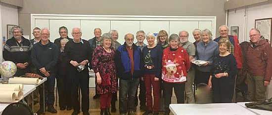
December 2019 Members’ Evening
Audrey Brown began the evening by sharing photos of some wonderful garnets from her recent geological trip to Norway. She explained how they come to be found in seemingly impossible rock (apparently an ancient subducted area broke off & came back up the way it had gone down!). Clive Boulter then told us how he & friends have been walking the area between Side Pike & Pike o’Blisco & believe they have found clear evidence of steeply dipping faults, typical of caldera wall collapse. This challenges widely accepted claims of gentle slopes, & suggests the complexity of the area has been over-stated. Then 24 of us, including two guests, enjoyed some very good food & conversation before Kent Brooks told us about ‘The oldest rocks’ (from a meteorite), & brought along some superb samples for us to examine. Geoff Brambles finished off the evening with his highly entertaining ‘Rambles’, including a visit to Lincoln Cathedral, a mention of Shap granite, & a trip to Kendal Castle, where he wondered at where the building stones came from & was surprised by references to limestone roof tiles. – Chris Anderson
November 2019 Haematite Mineralization Lecture
Economic haematite mineralization occurs at several sites along the margins of the East Irish Sea Basin. The origins of these iron deposits are poorly understood, with written explanations dating back to the early 1800s. In 1977 the BGS published a speculative model of how they might have formed. Dr Stephen Crowley, from the University of Liverpool made it clear from the start of his talk that the source of the ore deposits is his passion. He guided us through the arguments about their formation, testing each component of the various explanations by reference to the evidence. He dealt easily with the calculations required, but was careful to give us the ‘bottom line’, to ensure the audience of 35 members & 3 visitors followed his logic. – Chris Anderson
October 2019 Yunan Fossils Lecture
Prof Derek Siveter, Oxford University, treated 31 members to a multitude of slides showing early Cambrian fossils (520 million years old), part of the thousands of fossils found in the mudstones of the Chengjiang area, Yunnan Province, South-West China, since their first discovery in 1984. The fossils are remarkable for several reasons including their variety combined with their age, & the fact that their soft tissue has been preserved in fine detail, not just their hard shells. This detail allows the fossils to be compared to modern creatures, & to better understand the early evolution of animal life. – C. Anderson
September 2019 Joint Lecture with Cumberland Geological Society
About 12 members of the WGS joined members of the CGS in the Methodist Church Hall in Penrith to listen to Dr Tom Challands (University of Edinburgh), talking about ‘Scotland’s Jurassic Park’ & the new fossil discoveries on the Isle of Skye. Tom & his team have found plenty of fossils on coastal rocks revealed by high tides - & as quickly covered again - so they have to work fast! They rely on good communication with the locals who help to protect the fossils & let Tom know when new rocks are revealed. Tom’s enthusiasm for these tiny fish fossils was catching & most of us went up to him at the end to examine some of the tiny specimens he had brought with him. – C. Anderson
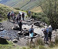
September 2019 St Bees Fieldtrip
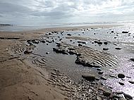
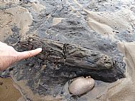
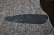
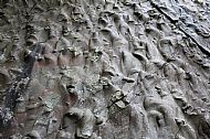
An excellent, well organized field trip with a variety of interesting outcrops & lovely weather was enjoyed by seven members who travelled to St Bees Head to meet field trip leader Sylvia & Peter Woodhead (WGS) at the first location of the day, Birkhams Quarry. The quarry produces small quantities of high-quality building stone from the St Bees Sandstone Formation (SBSF) for bespoke projects in the UK and internationally. The SBSF comprises mainly red/brown sandstone deposited by a large braided river system - the Budleighensis River - transporting siliciclastics northwards through an arid continental environment from its distal southern source in the Amorican Mountains. The SBSF forms the lower part of the Sherwood Sandstone Group which is early Triassic in age. We spent the morning in Birkhams Quarry where quarry manager Steve Boam gave us an interesting talk about the quarry, its history, the extraction process and the destination of this high-quality stone. Several faces in the quarry have been preserved and show large stacked channel complexes and interbedded mudstone horizons. Outside the quarry several large blocks have been placed by the quarry owners for inspection by visitors. The blocks contain many sedimentary structures and textures that give an insight into the depositional history of the SBSF including ripples, trough bedding and rip up mud clasts suggesting fluvial channel and playa lake deposits. Our second location was the cliffs south of St Bees village carpark where we examined the deformed Holocene glacial deposits. The cliffs provide excellent exposure illustrating complex ice induced tectonic processes such as compression structures with thrusts, folds and detachments. We had an unexpected bonus as the receding tide revealed good exposure of a submerged Holocene forest. Dated around 9000 years, the multiple tree stumps are the remnant of a forest that grew in the area when post glacial sea levels were significantly lower than today. – Richard Wrigley
The remains of the fossilised forest
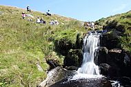
August 2019 Glenderaterra Fieldtrip
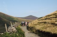
On a brilliant, sunny day, Bernard Skillerne de Bristowe (WGS) led 15 of us (including four guests) on a 2-mile stroll along the Glenderaterra at Threlkeld. We saw plenty of evidence of mineralisation & contact metamorphism. Several of our stops were near to where streams have cut through the rock e.g. Roughten Gill, with lots of debris to pick up & examine. The going got a bit tougher when Bernard led us up & across the fell for about half a mile (passing some large erratics), to show us an interesting contact point within a stream bed (Sinen Gill), where we enjoyed our lunch. We then continued up the hillside to examine various exposures including some with beautiful folding. As usual, Bernard challenged us to describe what we saw (& to come up with explanations), & then used his whiteboard to tell us what was actually going on! - Chris Anderson
Heading north (left); Roughten Gill (centre); Lunch at Sinen Gill (right)
July 2019 Shap Pink Quarry Fieldtrip
Christine Arkwright, true to her OU background, started this fieldtrip by explaining how Shap granite was formed & how it gets its distinctive look & colouring, then turned us loose on the many sample blocks set around the quarry. Sixteen of us (including 2 visitors & 1 guest) thoroughly enjoyed this opportunity, with lots of cries of ‘Come look at this!’. We were quite happy exploring until time came to move on to the Shap Wells Inn, where we had been given permission to eat our sandwiches on their covered entrance terrace. This was fortuitous, as by lunchtime a heavy, drizzly rain had set in which made the walk after lunch to the top of the stream, through an overgrown rhododendron ‘tunnel’ quite memorable! We also followed the meadow path by the river on the other side of the hotel, to take a walk back down through quite a lot of geological history! – C. Anderson
Examining boulders at Shap quarry (left) Shap granite (centre) A spectacular dark enclave (right)
June 2019 Heysham Fieldtrip
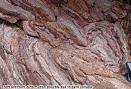
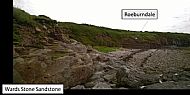
On a lovely sunny day, 13 members (& one visitor) joined our leaders Barbara Gordon & Paul Kabrna to examine Permian and Carboniferous sediments on the margin of the Irish Sea. The first location was to examine the Permian sediments exposed on the foreshore at Heysham power station. The sequence comprises red sandstone, with channel structures and several white leached beds. The leaching results from hematite dissolution, probably by basin fluids associated with hydrocarbon generation and migration in the East Irish Sea Basin. Without direct evidence a Permian age was suggested for the sandstones based on lithology and stratigraphic considerations. Our leaders took us through the caravan park & down onto the beach to view the Carboniferous sequence exposed in the cliffs at Heysham Head. The section was originally part of the Wards Stone Sandstone Formation.
Following our lunch break, we visited St Peter’s Church where we were treated to a talk about its history & Viking Heritage. We then went up the lane to the ruined St Patrick’s Chapel to the carved rock graves before walking along the shore to examine the excellent cliff exposure of gently dipping interbedded WSS & Roeburndale mudstone. Bed thickness varied through the section from a few centimeters to several metres with some good examples of large sandstone filled channels with erosive bases and graded bedding. One particular bed had flow structures and a grey limestone rip up clasts suggesting a mass transport deposit. Several pieces of fossil tree were found in sandstone suggesting transport into the delta via the channel sandstones in a near shore delta top environment. Several mudstone beds showed chaotic structures, evidence of soft sediment deformation. The beds were displaced at several places along the cliff section by fault zones. – Richard Wrigley
Soft deposit deformation (left); WSS (centre); WSS & Roeburndale mudstone at site 3 (right)
April 2019 Two quarries & a rock park (with OUGS) Fieldtrip
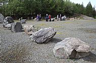
There was very little walking on this trip, led by Audrey Brown (WGS), as we travelled by car from site to site, but there was plenty of discussion & investigation. And, as Audrey had set questions for each site, a bit of competition between the fourteen of us! At Brown Howe Quarry (pink granite roadstone), near Coniston, we were able to admire the new interpretation board, put up by Cumbria GeoConservation (it won an Award for Excellence for a GA Curry Fund sponsored project). Eccle Riggs Quarry (sandstone), near Broughton, also known as the ‘donkey stones’ – possibly because the cliff face is like ripples in sand – was a surprise to those who had never seen it before. We had our lunch at Millom Rock Park, overlooking Ghyll Scaur Quarry, before spending a happy hour or so wandering round the display of large boulders from around the region, brought together as a rock park by the quarry owners. – C. Anderson
Flute casts at Eccle Riggs Quarry (left) & display rocks at Millom Rock Park (right)
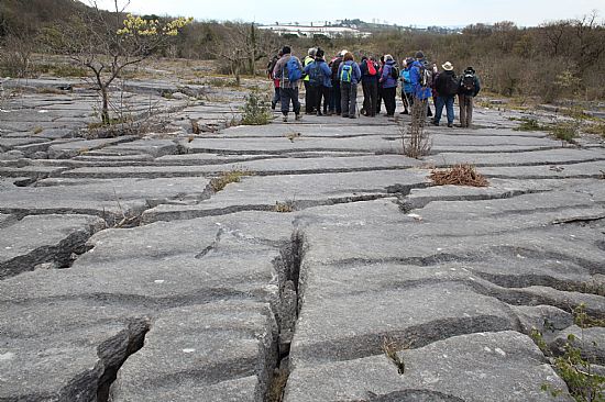
April 2019 Holmepark Fell Fieldtrip
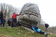
Dr Peter Standing (WGS) led 20 members & 7 guests on a short, easy walk onto the western part of Clawthorpe National Nature Reserve to look at fine karst & karren features, & some of the UK’s deepest runnels, on the limestone pavement. We also saw evidence of a competition of strength & skill between two of the best limestone workers! We then walked up the track to the Holme Park Quarry Geo Viewpoint, where Mike Balderstone (WGS) told us about the history of the quarry & what could be seen from the viewpoint. We then returned to the cars & drove to Hutton Roof Village Hall, where Peter treated us all to a lovely buffet lunch (made by village volunteers) & a presentation on the geology of the area (including Peter’s wonderful Geotrail booklets). Following lunch, Peter led us on a 3km circular walk from the Village Hall to The Rakes (recently restored by volunteers). This is a superb site that is internationally known & well worth the 100 metres of ascent. (Sadly, Peter died in November so this was his last fieldtrip for us.) – C. Anderson
An interesting erratic at Hutton Roof (left) Limestone pavement on Clawthorpe Fell (right)
March 2019 The Ertsberg-Grasberg Mine Film & Lecture
Professor Kent Brooks (WGS) was able to talk about the E-G mine in West Papua from personal experience. He showed a film that included how this rich site came to be discovered, how the mining company solved the problem of how to get plant up to this apparently inaccessible spot high in the rugged & precipitous mountains, & how they got the valuable ore (gold & copper) down. The film crew interviewed people who worked at the mine, including geologists, managers, & a local man who seemed to have almost single-handedly created the track to the mine through terrifyingly daring use of his excavator! Kent would stop the film to explain things & also answered questions at the end. – C. Anderson
February 2019 AGM & Presidential Address – Underground Space
The World Economic Forum suggests that some 60% of the area expected to be ‘urban’ by 2030 has not yet been built. Another prediction suggests that the world’s top 600 cities would be expected to generate 65% of economic growth by 2025. Such transformational change in urban environments & infrastructure will be more sustainable, & resilient, where geological modelling of the sub-surface has been placed at the forefront of future planning. Using highly complex examples from his own work as a mapping geologist, Dr Graham Leslie (BGS Scotland), demonstrated the extent to which robust geological understanding of the sub-surface can be conceived of, mapped, modelled, & communicated to the key authorities & so help them create this futuristic landscape. – C. Anderson
January 2019 Carbon Capture & Storage Lecture
Prof. Michael Stephenson (Director of Science & Technology, BGS Keyworth), described how carbon dioxide came to be ‘captured’ in very high quantities by early tree-like plants & laid down during the carboniferous period. This capture triggered a reverse greenhouse effect & mini-ice-age. The burning of carbon-based fuels releases CO2 back into the atmosphere. From the start of the industrial revolution, with its reliance on such fuels, CO2 levels have risen dramatically. Michael explained what Carbon Capture & Storage involves (collecting CO2 at site of emissions then storing it in rocks, from which it cannot escape, by displacing water & replacing with CO2). Currently, capturing CO2 emissions is a costly process & there are few examples of where it has been both captured & stored. However, the BGS has modelled how CCS might work in different rocks, how much could be stored, & when saturation point would be reached. Unfortunately, CCS could only deal with a small proportion of emissions, so reducing reliance on ‘fossil fuels’ is vital. – C. Anderson
2018 Lectures & Fieldtrips
Our 2018 events appeared in full in our 2018 Proceedings (published in March 2019), which members receive as part of their membership. The summaries (below) are to give you an idea of what to expect if you decide to join us for a lecture or fieldtrip.
December 2018 Members’ Evening
The December 2018 Members’ Evening & Jacob’s Join was a great success with 27 members enjoying good food, good company & super presentations. Audrey Brown brought her collection of prehistoric stone axes & told us what the experts had said about them. Kent Brooks brought his modern stone axe, purchased from a village in Papua New Guinea, of the kind still in use there. The manufacture of the axes from local stone had made the village rich. Audrey also gave us the sad news that our local footprints of the earliest known land creature (a myriapod), are in fact those of a water-living one on its last legs! Brian Kettle’s slideshow was a selection from Joan Clark's superb photographic archive (which gave us ideas for future fieldtrips). John Wood explained how the less well-known McNab’s ‘fossil’ trees on Mull were formed (with his wife acting as scale on photographs). Clive Boulter described an ignimbrite outcrop & how ignimbrite is formed. He also posed us the challenge of locating interesting fault patterns in local limestone. Geoff Brambles presented us with new & old locations of, & uses for, Shap granite along with some lovely ‘marble’. (If you want to view the rare sponge fossil to the left of the entrance to Bridge Mills, take a lens.) Vic Parsons’ analysis of names used for limestone on various local geological maps reassured us that, if we are confused by the variety of names used, we are not alone - the British Geological Survey mappers appear to be even more so! - Chris Anderson
November 2018 Lecture
Recent studies of garnet from the Scottish Highlands have questioned some key concepts of progressive metamorphism (that is, that minerals will form in a specific order under high pressure & at high temperatures out of molten rock). Dr. Tim Dempster’s talk on ‘Garnet Grain Boundaries’ described what he has found using high-magnitude microscopes to analyse faults in the garnet. He has also looked at internal zoning patterns (where garnet appears within the rock). His research suggests that garnet formation is more complex than has been thought, and that any explanation needs to include multiple factors in addition to heat & pressure. Dr. Dempster’s micro-scale observations have implications for our understanding of large-scale changes that occur in continental crust during mountain building. - Chris Anderson
October 2018 Lecture
Over 50 people attended Prof. Gillian Foulger’s talk on ‘Plates vs Plumes: A geological controversy’. The conventional view is that ‘hotspot’ volcanic islands are produced by a mantle plume, a rising column of magma that originates at the core- mantle boundary and rises through the mantle and crust to reach the surface. Prof. Foulger discussed the alternative view, increasingly being accepted by those working in the field, that the core and mantle are not involved and that the magma erupted at volcanic islands is simply produced by melting of the crust due to crustal extension, which allows magma to leak to the surface. She considered various predictions which, if true, would confirm the plume hypothesis and showed that most of them fail. Not everyone in the audience was wholly convinced and a lively question and answer session ensued. - Audrey Brown
September 2018 Joint Lecture with CGS
Ten WGS members joined Cumberland Geological Society members at the joint CGS/WGS lecture, held in Penrith. Prof. David Harper’s talk on Mass Extinctions examined competing theories to explain mass extinctions (MEs), focussing on five of them. A species might be expected to survive for 5 million years, but a ME may considerably shorten this. Many theories to explain MEs have focussed on external influences, such as asteroids hitting the earth (which may indeed explain one of them), or cyclical changes in the earth’s climate (once a popular idea, Prof Harper thought this unlikely). Prof. Harper suggested that there is now considerable geological evidence of when ice ages occurred & that most MEs happened during ice ages. Rather than looking above (to asteroids etc) for explanations, we should be looking down at what the rocks can tell us. (Go to The International Commission on Stratigraphy website at www.stratigraphy.org for an International Chronostratigraphic Chart & some wonderful photos.) - Chris Anderson
September 2018 Fieldtrip
Force Crag Mine is owned by the National Trust. We were lucky to have the local NT manager, plus two experienced & enthusiastic volunteers to show us round. One volunteer explained about the local geology & took us to look at the two innovative ponds sited below the mine, designed to remove impurities from run-off, & showed us mine entrances & adits. The other guided us through the mine buildings & explained how minerals were extracted from the rock. One of our members had twice been employed at the mine so was able to add interesting details about the production process & machinery. - Chris Anderson
August 2017 Fieldtrip
On a bright but breezy day, Clive Boulter & Duncan Woodcock led us on a gentle walk by the River Keer to examine the banks of slag, dumped there from the Carnforth Ironworks some 100 years ago. (Vic Parsons gave us some background to this, with a brief history of the ironworks.) Clive & Duncan explained that the slag had been hot when it had been deposited here. This meant that these raised banks shared some features with volcanic lava flows, & though it had the appearance of rock, it was quite soft beneath the weathered crust. They then encouraged us to look carefully at the slag in order to identify some of these flow features for ourselves. When we reached Morecambe Bay, the more intrepid of us scrambled down the bank to look at minerals that had formed in the slag! – Chris Anderson
July 2018 Fieldtrip
This fieldtrip to Eskdale, led by David Kelly, was to look at granite & haematite mineralisation. I was unable to attend, but if you did & you would be willing to write a short summary (100-250 words), please let me know. – Chris Anderson
June 2018 Fieldtrip
Bernard Skillerne de Bristowe adopted a Socratic method in this walk by the Craven Fault at Ingleton, challenging us to explain the pattern of faults & folding that we (thought we) observed (& not happy until we had come up with at least six explanations for each feature). Helpfully, he used a whiteboard to illustrate these patterns. When we reached the fell beneath Ingleton summit, we continued this examination by noting differences in the areas of limestone pavement that we were crossing. Bernard rewarded our efforts by taking us to where we had a glorious view over the valley before our downhill return to Ingleton village. - Chris Anderson
June 2018 Fieldtrip & Jacob’s Join
It was a lovely warm evening when twenty WGS members met to share food & chat in the garden of the Chairman’s home. At about 6.30, most of us set off in shared cars up the Appleby Road for a geological walk led by Geoff Brambles. Geoff started us off by looking at calcite in local building stone, & then at rocks in the stream bed, & in the old buildings by the stream. (The owner of the renovated mill building allowed us to look through her window at the mill stones incorporated into her floor!) We then followed the stream, with Geoff pointing out various beds & faults, before a gentle amble back to the cars. – Chris Anderson
May 2018 Fieldtrip
This three-day fieldtrip to Mull was led by Ian Williamson, who had surveyed the area when he worked for the BGS so knew the geology well. He provided us with excellent handouts via email, that informed us about what we might see. Ian catered well with a group of differing abilities, taking us on relatively gentle beach walks in the morning, then more strenuous upland or coastal path walks in the afternoon. He was also very complimentary about the willingness of our group to clamber over rocks, along sheep tracks, & through bogs! All the effort was worthwhile as we saw some wonderful rock formations & outcrops. Highlights included an upland walk to a ring dyke & a coastal one to leaf fossils (disturbing a basking adder on the way back). We were also lucky to have experienced botanists with us, who delighted in pointing out native flora. While we were staying on Mull, most of us took the opportunity to visit Iona (beach, marble quarry, monastery & nunnery) & some to take the longer boat trip to Staffa (Fingal’s Cave & nesting puffins). - Chris Anderson
April 2018 Fieldtrip
The Cross Fell Inlier (an area of much older, highly faulted & folded rocks surrounded by younger rocks), was clear on the geology map that our leader, Karl Egeland-Eriksen showed us as we left Dufton at the start of this fieldtrip. Karl led us up the valley, often following old miners’ tracks, pointing out adits, faults, outcrops & quarries & the general topography as we went. Highlights included looking for minerals in a microgranite wall, trying to work out what a large lump of Shap granite was doing by the side of a stream (imported by man not nature), & fossicking for fossils off the path on the way up to the Great Whin Sill. – Chris Anderson
March 2018 Lecture
Prof. Christine Peirce is a geophysicist who has been investigating the earth beneath the seas for over 30 years. She is also leading the fitness-for-science trials of the UK research vessel the Sir David Attenborough (that carries small subs known as Boaty McBoatface). Our oceans can be up to 10 km deep and so can only be examined through water. Remote-sounding, where researchers record echoes coming back from the sea floor, allow them to map what they cannot see. In a fascinating talk, Prof. Peirce described the many & increasingly detailed ways in which the complex ocean floor is being recorded & measured. This work has significant commercial potential as many of the rare materials that are required to make items such as mobile phones, are found near deep water vents. It is also revealing new things about how these vents develop. - Chris Anderson
February 2018 Lecture
Prof. Harry Pinkerton, in his talk on dealing with unexpected eruptions on volcanic islands, explained how eruptions are difficult to predict & that when they occur on an island, they may have extra problems associated with them. For example, if the flow reaches the sea there is likely to be an explosive effect (such as Krakatoa), though on Heimay, cooling the flow with sea water stopped it reaching the sea. Signs such as ground deformation can show where molten rock & water is moving under the ground, & this can be measured using GPS sensors. However, the lava could emerge at any point. Those who must make the decision to evacuate have to do so well before there is serious damage to people or property. Evacuation can take a long time, for instance, on Ambae it took nine days to evacuate 11,000 people (& that volcano was only having a ‘moderate eruption’). Examining how volcanoes have behaved in the past, modelling eruptions in the lab, & monitoring activity in the field can all contribute to moving from ‘forecasting’ that an eruption will occur to ‘predicting’ when it will happen. - Chris Anderson
January 2018 Lecture
Dr. Graham Leslie’s inaugural Presidential Lecture on “Singapore: What place geology in future Singapore?”, was accompanied by some wonderful maps & photographs of the area. Dr. Leslie began by describing modern Singapore & the policy to develop underground storage space, which in turn requires high quality maps of the sub-surface to assist this development. As a Senior Mapping Geologist with the BGS, he has been involved in this mapping work since 2014 & has got to know the area well. Dr. Leslie went on to describe the geology of the area, relating it to our local Lake District geology where appropriate. He also highlighted some of the problems associated with the tropics e.g. very soft, weathered, soil-like rock can be found very deep down! - Chris Anderson
December 2017 Members’ Evening
Twenty-five members attended the December 2017 Members’ Evening to listen to a record number of presentations. Some presentations looked forward (Vic Parsons with his map of Mull to prepare for our 3-day excursion in May; Duncan Woodcock with his Komatiite found at Hest Bank - & by the Keer which we will visit in August); some looked back (Peter Standing on Palaeopits from our June visit to Holme Park); other speakers described interesting places they had visited (Brian Kettle on La Mesa Roldan, Southern Spain; Dennis Pook on Hartland Point, North Devon; Geoff Brambles on stones of Kendal & further afield); & one was a revelation (Melville Thomson on how the Cadbury’s Bournville wrapper got its distinctive ‘sheen’ by being rubbed by a stone). Table displays included Melville’s ‘polishing’ stone; Audrey Brown’s model of an Easter Island statue; Kent Brooks’ sample of tungsten; & Vic Parsons’ photographic display from the WGS archive. Chris Anderson finished the evening with a brief review of 2017. She thanked all those who work to ensure the smooth-running of the society, & the high quality & variety of our lecture & field trip programme. - Chris Anderson
November 2017 Lecture
Dr. Nick Riley’s talk on UK Shale Gas (and why we need to explore for it), described UK patterns of fuel use and fuel production. Generally, though our fuel use has not increased over the last thirty years or so, mainly due to greater fuel efficiency via improved technology, our home production of gas fuel has almost come to an end, and our reliance on gas as a fuel has increased dramatically. This means we are having to import gas, with consequent loss of internal revenue which has an impact on the UK economy. In some cases, this also leads to our contribution to greenhouse gas emissions being increased. We must also meet government and world targets for reducing gas emissions. Dr. Riley then briefly described where shale gas occurs, the impact of exploring for it, and the potential of alternative sources of energy to satisfy UK needs compared to shale gas. - Chris Anderson
October 2017 Lecture
Prof. Chris Clarke’s fascinating talk described the work that he and a large team of geologists have been carrying out over the last few years to produce a highly detailed record of the retreat of the last Irish-British ice sheet. The work includes examining LIDOR (aerial) images of the whole of Great Britain which provide superb evidence of all the drumlins and other glacial features, field walks to identify and date erratic boulders that have not been moved since deposition, and taking core samples from the sea floor to find the extent of the ice sheet & date its retreat through carbon-dating of shells. The aim of this very intensive and expensive work is to provide an exhaustive description of ice-sheet retreat which can be used to test modern theories which claim to predict how ice-sheets behave when they melt.
Chris Anderson
September 2017 Joint Lecture with CGS
There was a good turn-out of WGS members at the September joint lecture with the Cumberland Geological Society, held in Penrith. Prof. Danielle Schreve gave a well-illustrated talk about the work she and her team have been doing, excavating the floor of a limestone cave in the Ebbor Gorge in Somerset. To date, they have sifted 120 tons of material, and found bone fossils from a wide range of animals, some now extinct, some no longer native to the region, dating back to at least 40,000 years ago. This period includes some massive & rapid changes in environment, including the extinction of Neanderthals and woolly rhinos and mammoths. The layers of deposits provide an unbroken palaeoenvironmental record, which includes the period when the area was re-colonised by homo sapiens. Professor Schreve told us that the findings show that cold-climate taxa persisted into the Holocene period, and supports the idea of ‘disharmonious’ fauna and a northern refugium, that is, an area where plants and animals continued to thrive despite disadvantageous climate change, and that these findings have implications for conservation biologists.
Chris Anderson
September 2017 Fieldtrip
We were badly let down by the weather for our September fieldtrip to Seathwaite Fell in Borrowdale, with heavy showers & cold winds reducing the temperature considerably. (Though as we have had good weather for every other fieldtrip this year, we cannot really complain.) However, we did not let the weather stop us! Our leader, Clive Boulter led us on a trip that included some wonderful rock outcrops that many of us would never have found on our own. He also circulated, in advance, a comprehensive description of where we were going, and why, and what we would see, with some super photographs of the outcrops, plus maps and diagrams. This is well worth looking at, as it gives a good idea of what we saw. You might also have a look at the super photographs from our trip, taken by Mike Coates, that he has added to the WGS website. A bonus to this trip was that it was in conjunction with the Cumbria Geological Society, which gave us the chance to meet new people and to catch up with CGS friends.
Chris Anderson
July 2017 Fieldtrip (2)
James Fielding, and three of his colleagues from Southampton, led us up the valley from Glenridding to the disused lead workings, pointing out buildings of interest on the way, including rows of lead-miners’ cottages, the gunpowder house, the company store, and, working its way to a high point, the mile or so long chimney flu built to remove noxious fumes. The mining here was lucrative as the rock had a high lead (with some silver) content. From the early 1800s, it resulted in some massive spoil heaps, with the operation gradually moving down the hillside. When we reached the remains of the dressing floor (our highest point), we spent some time looking for evidence of lead in the remains, and found plenty of good examples. James told us that the deposits in Ullswater are highly contaminated with lead, and that a Glenridding farmer in the 1880s successfully sued the mine owners for the death of his sheep due to lead contamination on his grazing land. This is possibly the first modern-day example of an environmental law suit!
Chris Anderson
July 2017 Fieldtrip (1)
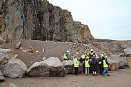
The excursion to Spireslack Opencast Surface Mine involved a long journey for 17 of us, but was well worth the effort. Graham Leslie & Mike Browne told us about the geology, industry, and social history of the area. Highlights included viewing the great slope of limestone pavement that was cleared to provide a back wall when the highly mechanised open-cast mining started. As this was less than 15 years ago, we had the rare opportunity to be able to readily identify folding, major and minor faulting, and pavement collapse. On the opposite side of the canyon, the coal measures were revealed, including those showing evidence of early, underground workings in the form of wooden pit props and nails to hang bate boxes. The homes and buildings that supported this mining community had all been razed to the ground when this mining ended. I think we all admired Graham’s enthusiasm for the site and agreed that it is a fantastic educational resource.
Chris Anderson
June 2017 Fieldtrip
Our June fieldtrip to Holme Park Quarry, led by WGS member Peter Standing, was well attended by 15 members & 3 guests, all enthusiastic to see the quarry. Peter was keen to share the latest research on limestone environments, such as how acidic they are (or not), and the temperature within the deep fissures, as well as pointing out general features of the limestone pavement. However, the highlight of the trip was the chance to view the palaeokarst surfaces that had been revealed by the quarrying and the palaeopits (believed to be where ancient ‘trees’ grew), which were impressive. It was also wonderful to have a chance to rummage for fossils in the Woodbine shale. There were plenty of fossils, but though they fell apart in our hands, it was great to have the chance to look for them! Special thanks go to the site manager, Steve Rigby, who gently shepherded us around the site, and to Alan Pentecost, an expert on mosses & lichens, who generously shared his knowledge with us & seemed able to identify everything we passed his way.
Chris Anderson
May 2017 Fieldtrip
We had another lovely day for the May field trip, led by Susan Beale, a WGS member, which met at Mosedale Bridge. The Caldew Valley was new to many of us, and Susan encouraged us to examine the landscape, and see how the geology had changed it. Susan was keen to get us involved, and so started the day by asking us to search for (and try to identify), a range of pebbles in the river bed (which we did with gusto). Susan also had us busy with our lenses looking at the grain size of igneous rocks, and explaining to us the impact of cooling rates. Our walk up the Caldew Valley included examining some intriguing & beautiful river outcrops, and identifying contact points where the rock changed from igneous to metamorphic. The subject of minerals and how they form was of great interest to many of us, and we enjoyed searching for evidence of them. A bonus to this trip was our lunch stop at the Quaker Meeting House, an early building with some interesting features, in a lovely, peaceful environment.
Chris Anderson
April 2017 Fieldtrip
We had a beautiful, sunny day for our first fieldtrip to Ingleton Falls. Hilary Davis, our leader, encouraged the fifteen of us who went to complete our own map of geological features, and demonstrated how to measure dip and strike (some of us have a go). Highlights included seeing an unconformity very close to, and getting to the top of the falls at Kings Vale, with a view back down the trail.
Chris Anderson